Mars
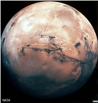
Unpiloted spacecraft have allowed scientists to determine thatMars’s atmosphere is mostly made up of carbon dioxide (CO2), with small amountsof nitrogen, oxygen, and water vapour. Owing to the thinness of the atmosphere,daily temperatures often vary by as much as 100° C (180° F). Surfacetemperatures are too cold and surface pressures too low for water to exist in aliquid state on Mars, so the planet resembles a cold, high-altitude desert.This view is centred on the Valles Marineris, a great chasm some 4,000 km(2,500 mi) long.
NASAMars (planet), planet named after the Romangod of war, the fourth from the Sun and the third in order of increasing mass.Mars has two small, heavily cratered satellites, or moons, Phobos and Deimos,which some astronomers consider to be asteroid-like objects captured by theplanet very early in its history. Phobos is about 21 km (13 mi) across; Deimos,only about 12 km (7y mi).
MarsFacts and Figures
|
| Equatorial radius | 3,396 km (2,111 mi) |
|
| Equatorial inclination | 25.2° |
|
| Mass | 6.42×10²³ kg |
|
| Average density | 3.9 g/cm3 |
|
| Rotational period | 1.03 days |
|
| Orbital period | 1.881 years |
|
| Average distance from the Sun | 228 million km (142 million mi) |
|
| Perihelion | 206.7 million km (128.5 million mi) |
|
| Aphelion | 249.3 million km (155 million mi) |
|
| Orbital eccentricity | 0.0935 |
|
| Orbital inclination | 1.85° |
|
| Moons | 2 |
|
| Source |
| Data are from the US Naval Observatory's annual Astronomical Almanac and various other publications. |
When viewed without a telescope, Mars is a reddishobject whose brightness depends on its distance from the Earth. At its closest(56 million km/35 million mi), Mars is, after Venus, the brightest object inthe night sky. Mars is best observed when it is both at opposition (directlyopposite the Sun in the sky) and near perihelion (its closest approach to theSun). Such favourable circumstances repeat every 15 or 17 years.
Through a telescope Mars is seen to have brightorange regions and darker, less red areas, the outlines and tones of whichchange with Martian seasons. (Because of the 25° tilt of its axis and theeccentricity of its orbit, Mars has short, relatively warm southern summers andlong, relatively cold southern winters.) The reddish colour of the planetresults from its heavily oxidized, or rusted, surface. The dark areas arethought to consist of rocks similar to terrestrial basalts, the surfaces ofwhich have been weathered and oxidized. The brighter areas seem to consist ofsimilar but even more weathered and oxidized material and apparently containmore fine, dust-sized particles than do the dark regions. The mineralscapolite, relatively rare on Earth, seems widespread; it may serve as a storefor carbon dioxide (CO2) from the atmosphere.
Conspicuous bright caps, composed of frozen water and CO2,mark the planet’s polar regions. Their seasonal cycle has been followed formore than two centuries. Each Martian autumn, bright clouds form over theappropriate pole. Below this so-called polar hood, a thin cap of carbon dioxidefrost is deposited during the autumn and winter. By late winter, the cap mayextend down to latitudes of 45°. By the spring, and the end of the long polarnight, the polar hood dissipates, revealing the winter frost cap; the cap’sboundary then gradually recedes poleward as sunlight evaporates the accumulatedfrost. By midsummer the steady recession of the annual cap stops, and a brightdeposit of frost and ice survives until the following autumn. These remnantpolar caps consist mostly of frozen water. They are about 300 km (185 mi) wideat the south pole and 1,000 km (620 mi) wide in the north. Although their truethickness is not known, they must contain ice and frozen gases to a thicknessof possibly 2 km (1€ mi).
In addition to the polar hoods—thought toconsist largely of frozen CO2—other clouds are common on the planet.High-altitude hazes and localized water-ice clouds are observed. The latterresult from the cooling associated with air masses rising over elevated obstacles.Extensive yellow clouds, consisting of dust lifted by Martian winds, areespecially prominent during southern summers.
| III |
| OBSERVATION BY SPACECRAFT |
Mars Polar Lander
Mars Polar Lander was scheduled to reach the planet Mars in late1999, however it apparently crashed on landing and disappeared without trace.The lander was designed to descend to the surface with a parachute and with itsown braking rockets. Once there, its mission was to study the weather andclimate near Mars's south pole.
© Microsoft Corporation. All Rights Reserved.
The first spacecraft views of the planet wereobtained in 1965 when Mariner 4 flew past Mars and revealed the presence ofcraters on its surface, and further information was gained in 1969 from thefly-by missions of Mariners 6 and 7. Then, in 1971, Mariner 9 went intoorbit around Mars. It studied the planet for almost a year, giving scientiststheir first comprehensive global view of Mars and the first detailed images ofits satellites, Phobos and Deimos. In 1976 two Viking landers touched downsuccessfully on Mars and carried out the first direct investigations of theatmosphere and surface. The Viking mission also included two orbiters thatstudied the planet for almost two full Martian years (from 1976 to 1980). In1988 the Soviet Union sent two probes to land on Phobos; both missions failed,although one relayed back some data and photographs before radio contact waslost.
In the mid-1990s a new exploratory effortbegan, with pairs of spacecraft being sent to the planet every two years (tocoincide with each Mars opposition). The US Mars Observer probe, launched in1994, failed during 1995 just as it was entering Mars orbit, but on July 4,1997, Mars Pathfinder, comprising a 895 kg (1,973 lb) lander and a 10 kg (22lb) rover (called Sojourner), successfully put down in Ares Vallis, a sitecarefully selected at the mouth of a major outflow channel system in ChrysePlanitia. Multi-spectral cameras identified several different rock types andvariable degrees of weathering. An alpha-proton spectrometer aboard Sojournerobtained chemical analyses of selected boulders, as a result of which andesiticlavas were recorded for the first time. Sedimentary rocks containing pebbleswere also found. Some drifted material was finer than talcum powder, andseveral boulders had become coated by this strongly oxidized, windblown dustthat appears to be derived from the breakdown of basaltic bedrock. No organicor meteoritic matter was detected.
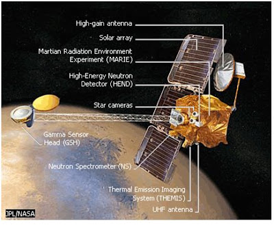
Mars Odyssey Spacecraft
NASA's Mars Odyssey spacecraft carried instruments designed todetermine the minerals that make up the surface of the planet. The spacecraftalso had instruments to analyse the amount of radiation present in the planet'sorbit. This data was required in order to help scientists establish how muchradiation protection a human mission to Mars might require.
JPL/NASA
The American Mars exploration programme sufferedsetbacks at the end of 1999 with the loss of two NASA spacecraft—the MarsClimate Orbiter and the Mars Polar Lander. However, the Mars Global Surveyor(MGS), launched in 1996, went into orbit and began a detailed topographicalmapping of the planet on April 1, 1999, using a laser altimeter that enablesmeasurements to be made to an accuracy of 2 m (6 ft). A map released by NASA in1999 revealed that the northern hemisphere is about 5 km (3 mi) lower inaltitude than the south, indicating that the northern regions may have held anyoceans that existed on Mars in the past. Further support was given to the oceantheory by the profile of the Martian crust produced by the MGS, which revealed200-km (125-mi) wide subterranean channels that would once have been surfacefeatures. The three-dimensional mapping also showed that the distance betweenthe highest and lowest points on Mars is one-and-a-half times as great as thatbetween Mount Everest and the deepest ocean trench on Earth, and that thethickness of the crust is about 80 km (50 mi) beneath the southern highlandsand Tharsis ridge, compared to about 35 km (22 mi) beneath the northernlowlands and Arabia Terra. In April 2001 another probe, Mars Odyssey, waslaunched; it reached the planet’s orbit in October 2001. In May 2002 scientistsannounced that the probe had detected large quantities of water-ice crystalsless than 1 m (3 ft) below the surface over much of the planet.

The Spirit Rover Lands on Mars
The panoramic camera on board the Spirit rover reveals the first360-degree view of the Martian surface. Part of the landing craft is visible inthis image taken in January 2004 after the Spirit spacecraft landed in GusevCrater, a region thought to be an ancient lake bed, located near the Martianequator.
© Microsoft Corporation. All Rights Reserved.
Three probes were launched to Mars in 2003—theEuropean Space Agency’s Mars Express and NASA’s two Mars Exploration Rovers.Mars Express went into orbit around Mars in December that year for a two-yearsurvey of the planet. As Mars Express approached the planet it released aBritish-built lander called Beagle 2, which was targeted to land on IsidisPlanitia, a lowland plain, but no communications were received from it. MarsExpress carried a stereoscopic camera, a spectrometer to map the mineralcomposition of the surface, other instruments to measure the composition of theatmosphere and plot its circulation, and a radar to penetrate the upper 2-3 km(1€-2 mi) of Martian crust in search of subsurface ice and water. Inan early finding, the spectrometer confirmed that the south polar cap wascomposed of water ice and frozen CO2, thereby achieving one of itsgoals, that of identifying water in some form on Mars.

Martian Rocks
This photograph, taken by the Mars Pathfinder lander in 1997,shows the surface of Mars littered with rocks. The lander had successfully putdown in Ares Vallis, which is at the mouth of a major outflow channel system inChryse Planitia.
NASA
In January 2004 two American landers, calledSpirit and Opportunity, touched down on opposite sides of the planet—Spirit ina crater called Gusev that is once thought to have held a lake, and Opportunityin an area called Meridiani Planum, where deposits of grey haematite, a mineralthat forms in the presence of water, have been detected. Both rovers weredesigned to spend at least three months exploring the surface, analysing rockand soil samples, but continued to function long beyond this limit. In August2005, NASA’s Mars Reconnaissance Orbiter was launched as a follow-up to theEuropean Space Agency’s Mars Express, and in August 2007 NASA’s Phoenix waslaunched with the aim of landing on the planet in May 2008 to explore itsclimate and geology and to continue the search for life. Next to leave for Marswill be NASA’s Mars Science Laboratory, due to be launched in 2009. Futuremissions will continue the exploration of the surface, leading eventually to areturn of Mars samples to Earth.
The Martian atmosphere consists largely of carbondioxide (95 per cent), with smaller quantities of nitrogen (2.7 per cent),argon (1.6 per cent), and oxygen (0.2 per cent), and trace amounts of watervapour, carbon monoxide, and noble gases. The atmospheric pressure at thesurface of Mars fluctuates by about 30 per cent owing to the seasonal freezingand evaporation of CO2 at the poles; the average is about 0.6 percent of that on Earth and equal to the pressure at a height of 35 km (22 mi) inthe Earth’s atmosphere. Surface temperatures vary greatly with time of day,season, and latitude. Maximum summer temperatures may reach 17° C (63° F), butaverage daily temperatures at the surface do not exceed -33° C (-27° F). Owingto the thinness of the atmosphere, daily temperature variations of 100° C (180°F) are common. Poleward of about 50° latitude, temperatures remain cold enough(less than -123° C/-189° F) throughout the winter for some of the atmosphere’sCO2 to freeze out into the white deposits that make up much of thepolar caps.
The amount of water vapour present in theMartian atmosphere is extremely small and variable. The concentration isgreatest near the edges of the receding polar caps in spring. Mars is like avery cold, high-altitude desert. Surface temperatures and pressures are too lowfor water to exist in the liquid state in most places on the planet, althoughit exists in frozen form at the poles and just below the surface.
At certain seasons, some areas on Mars are subjectto winds strong enough to move sand on the surface and to suspend dust in theatmosphere. In the southern hemisphere between late spring and early summer,when Mars is near perihelion and the heating of southern near-equatoriallatitudes is most intense, dust storms begin to form and may reach globalproportions, obscuring the planet’s surface for weeks or even months. The dustentrained in these clouds is very fine and takes a long time to settle.
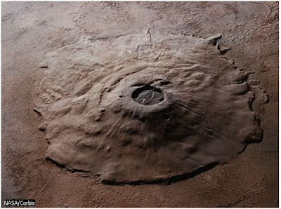
Olympus Mons
Olympus Mons, in the Tharsis region of Mars, is the highestknown mountain in the solar system, rising some 25 km (15y mi) above thesurrounding plain and measuring about 600 km (370 mi) across at the base. It isa shield volcano, now extinct, which built up over millions of years insuccessive eruptions.
NASA/Corbis
In terms of geodesy, the shape of Mars isnon-spherical: there is a major bulge over the volcanic region of Tharsis, anda smaller one on the opposite side of the planet, over Elysium. Beneath Tharsisisostatic compensation (thickening of the crust below ground as well as above,to support the mass of mountainous regions) is incomplete at shallow depths,indicating that the bulge must in part be supported dynamically. Muchcontroversy surrounds its development. There is a strong likelihood thatTharsis developed over a region of thin lithosphere (the outer rock layer ofthe planet), allowing long-lived constructional volcanism.
Flying Over Mars
The Viking orbiters took more than 50,000 pictures of thesurface of Mars. This animation was created by making a mosaic of Vikingorbiter images and enhancing the natural colour to make features more apparent.The path of the animation is along Valles Marineris, a system of Martiancanyons over 4,000 km (2,400 mi) long and over 7 km (4 mi) deep in some places.
NASA
The Martian surface can be divided into twoprovinces by a great circle inclined at about 30° to the equator. The southerntwo thirds of the planet consists of ancient cratered terrain dating from theplanet’s earliest history, when Mars and the other planets were subjected tointense meteoroidal bombardment. Considerable erosion and filling of even thelargest craters have occurred since then.
Mars Pathfinder Spacecraft
The Mars Pathfinder spacecraft, launched by the United States in1997, was made up of a lander containing weather equipment and cameras, and asmall rover, which explored the surface of Mars around the lander. The landerfolded up around the equipment and the rover for the journey to Mars, and thenunfolded when it reached the planet's surface.
© Microsoft Corporation. All Rights Reserved.
The northern third of Mars has a much lesscratered, and hence younger, surface, believed to be underlain largely byvolcanic flows. Two major centres of past volcanic activity have beenidentified: the Elysium plateau and the Tharsis ridge. Some of the solarsystem’s largest volcanoes occur in Tharsis. Olympus Mons, a structure showingall the characteristics of a basaltic shield volcano, reaches an elevation ofmore than 21.3 km (13ƒ mi) and measures more than 600 km (370 mi) across its base. Nodefinite evidence exists of current volcanic activity anywhere on the planet.
Faults and other features suggestive of crustalextension are widespread on Mars. The most spectacular feature is theequatorial canyon network, Valles Marineris, which runs eastward from the crestof the Tharsis ridge for some 4,000 km (2,500 mi), ending in a region of collapsedchaotic terrain at 15° south, 40° west. In places the canyon system is 600 km(370 mi) wide and 7 km (4y mi) deep. The rectilinear pattern of its side canyons and detailsof its canyon walls indicate that it developed largely in response to tectonicforces associated with the Tharsis ridge.

Searching for Water on Mars
Scientists believe that these channels in a crater wall on Marswere formed by water. The sharpness of the features and the lack of smallimpact craters covering them imply that the channels formed relatively recentlyin the history of the planet. Liquid water, therefore, could exist below thesurface of Mars.
NASA/Science Photo Library/Photo Researchers, Inc.
On the other hand, no features resulting fromlarge-scale compression have been found. Specifically, folded mountain belts,so common on Earth, are lacking, apparently indicating an absence of platetectonics. However, some scientists have suggested that during the earlyhistory of the planet some lateral crustal movements may have taken place. Thissuggests, in turn, that Mars may have developed a thicker lithosphere and mayhave had a thermal history rather different to that of the Earth. In 1999magnetic observations made by Mars Global Surveyor unexpectedly strengthenedthe case for plate tectonics in Mars's early history. They showed long stripsof rock with alternating magnetic polarities, similar to the pattern found onEarth's sea floors on either side of mid-ocean ridges where new crust is slowlyforming and spreading apart. This seems to indicate that at some point in itspast Mars's interior was hot enough both to produce a global magnetic field(which regularly switched direction, as the Earth's does) and to drive platetectonics.
Evidence of subsurface water ice prevails, especially inthe form of petal-shaped ejecta blankets around some craters, vast areas ofcollapsed chaotic terrain, and so-called patterned ground at high northernlatitudes. Among the more spectacular geological discoveries have been the hugevolcanoes of Tharsis, the equatorial canyon system, and numerous channels thatsuperficially resemble the valleys of dried-up rivers. Two major types ofchannels are known. Large outflow channels may have been formed by the suddencatastrophic release of vast amounts of liquid water from areas of collapsedchaotic terrain. Most of these channels drain from the higher southernhemisphere to the generally lower northern hemisphere. The cause of thelocalized melting of the ground ice in the source areas remains uncertain, butthese features probably date from the first third of the planet’s4.6-billion-year history. In addition to the large outflow channels, there arenumerous small channel-like features, which appear to pre-date the outflowchannels; erosion by liquid water is likely to be the cause of these, too,though the evidence is less compelling. Because liquid water cannot existpermanently on the surface of Mars today, the channels have been singled out asproof that the planet had higher pressures and warmer temperatures in the past.In the northern plains, there is considerable evidence for former strand linesand other shoreline landforms, which implies that shallow “palaeolakes” oncecovered a large part of this area. High-resolution images of the surface obtainedfrom Mars Global Surveyor have shown up features that suggest the possibilitythat water may have flowed over the Martian surface rather more recently,geologically speaking. Further than this, it was suggested in 2003 thatgeothermal activity driven by volcanic heat below ground may be able to forceunderground ice deposits to melt and briefly flow across the surface leavingtemporary “dark stains”, although evidence is inconclusive.
Yet the surface of Mars today is essentially awindblown desert. Vast expanses of sand dunes encircle the polar regions, andat much lower latitudes other wind-formed erosional features abound, allattesting to the efficacy of both depositional and erosional wind processes inthe current Mars environment.
Little is known about the interior of Mars. Theplanet’s relatively low mean density indicates that it cannot have an extensivemetallic core. Furthermore, any core that may be present is probably not fluid,because Mars does not have a measurable magnetic field. Judging from itsability to support such massive topological features as the Tharsis ridge, thecrust of Mars may be as thick as 200 km (125 mi)—five or six times as thick asthe Earth’s crust. A seismometer on board the Viking 2 lander failed to detectany definite “Marsquakes”.
The idea that life could, or even does, existon Mars has a long history. In 1877 the Italian astronomer GiovanniSchiaparelli claimed to have seen a planet-wide system of channels (Italian canali).The American astronomer Percival Lowell then popularized these faint lines ascanals and held them out as proof of a vast attempt by intelligent beings toirrigate an arid planet. Subsequent spacecraft observations have shown thatthere are no canals on Mars, and various other alleged proofs of life on theplanet have turned out to be equally illusory. The dark areas once thought tobe oases are not green, as contrast effects had made them seem to terrestrialobservers, and their spectra contain no evidence of organic materials. Theseasonal changes in the appearance of these areas are not due to any vegetativecycle, but to seasonal Martian winds blowing sterile sand and dust. Water isonly known to occur as ice on and below the surface and as trace amounts ofvapour or ice crystals in the Martian atmosphere. The strongest evidenceagainst the presence of life, however, is the thinness of the atmosphere andthe fact that the surface of the planet is exposed not only to lethal doses ofsolar ultraviolet radiation but also to the chemical effects of highlyoxidizing substances (such as hydrogen peroxide) produced by photochemistry.
Perhaps the most fundamental and far-reachingresult obtained by the Viking landers is that the Martian soil contains noorganic material (there is no reason to assume that the two landing sites arenot representative of the planet as a whole). Although small amounts of organicmolecules are continually being supplied to the surface of Mars by carbonaceousmeteoroids, this material is apparently destroyed before it has a chance toaccumulate. The results of the soil analysis for organic molecules carried outby the Viking landers provide no evidence for the existence of life.
A more difficult question is whether life has everexisted on Mars, given the strong evidence of climatic change and theindications of a previously warmer, thicker atmosphere. Suggestions thatstructures found in a meteorite discovered in Antarctica, which may have beenblasted off the Martian surface, were fossil traces of bacteria-like organismshave since been discounted. However, answering the question of life on Marswill probably involve collecting carefully selected subsurface samples andreturning them to Earth for detailed analysis.